

Every spring, ranchers face the same difficult challenge—trying to guess how much grass will be available for livestock to graze during the upcoming summer. In May, a new Grassland Productivity Forecast or “Grass-Cast” has published its first forecast to help producers in the northern Great Plains reduce this economically important source of uncertainty.
This new, experimental grassland forecast is supported by the U.S. Department of Agriculture’s (USDA) Agricultural Research Service (ARS), Natural Resources Conservation Service (NRCS), and the National Drought Mitigation Center (NDMC). Other collaborators include Colorado State University and the University of Arizona.
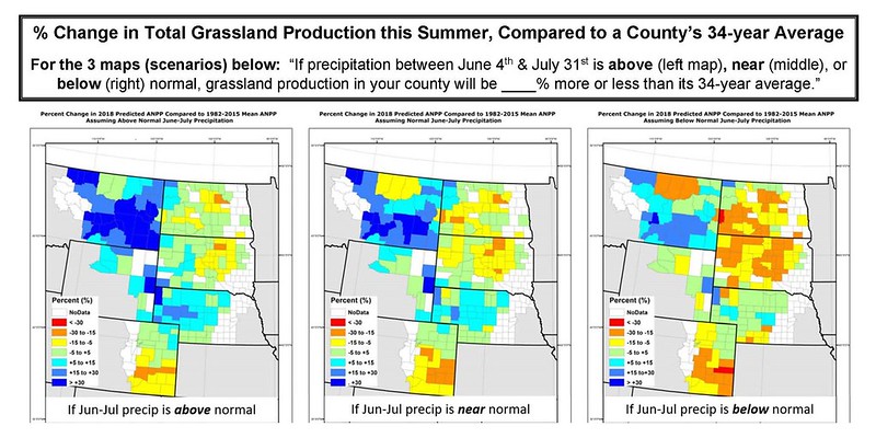
Grass-Cast uses more than 30 years of historical data about weather and vegetation growth—combined with seasonal precipitation forecasts—to predict if rangelands in individual counties are likely to produce above-normal, near-normal, or below-normal amounts of vegetation for grazing.
Grass-Cast’s accuracy improves as the growing season unfolds, so it should be consulted more than just once during the growing season. Grass-Cast maps are updated every two weeks to incorporate newly observed weather data and emerging trends in grazing conditions.
Grass-Cast provides ranchers and land managers with a range of what productivity might be in the upcoming growing season relative to their own county’s 30-year history. Ranchers and land managers will need to combine the forecast information with their knowledge of local soils, plant communities, topography, and other conditions as part of their decision-making process. Grass-Cast also gives ranchers a view of rangeland productivity in the broader region to help with larger-scale decision-making, such as determining where grazing resources might be more plentiful if their own region is at risk from drought.
Since Grass-Cast cannot tell the difference between desirable forage species and undesirable forage species, it is important for producers to know what proportion of a pasture is occupied by weeds, and how well those weeds respond to rain (or lack of rain) compared to the desirable species. Producers should monitor these different vegetation types to see if one is responding to the weather better than the other and adjust Grass-Cast’s productivity estimates accordingly. Grass-Cast does not directly account for local management practices, such as grazing intensity in previous years. Producers should therefore adjust Grass-Cast’s estimates accordingly.
Producers should not rely on Grass-Cast as a sole source for making management decisions. Similarly, public land managers should not use Grass-Cast as a sole source of information for setting stocking rates, determining turnout dates, or for other aspects of lease agreements, allotments or permits.
Visit the Grass-Cast website for the latest maps, an introductory video, program contacts, and other resources.