

Visit www.usda.gov/drought for the latest information regarding USDA’s Drought Disaster response and assistance.
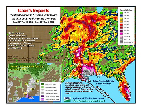
Hurricane Isaac moved ashore early Wednesday, August 29, in southeastern Louisiana with maximum sustained winds near 80 mph. Once inland, the storm steadily weakened, losing its tropical characteristics over Missouri on Saturday, September 1. Nevertheless, Isaac’s remnant circulation continued to drift across the eastern Corn Belt during the Labor Day weekend, generating locally heavy showers from the lower Midwest into the mid-Atlantic region. Storm-total rainfall reached 10 to 20 inches in the central Gulf Coast region, while some drought-affected areas in Arkansas, Missouri, and Illinois received in excess of 4 inches. In the Mid-South and lower Midwest, positive effects of Isaac’s rainfall included replenishment of soil moisture in preparation for the soft red winter wheat planting season and starting the process of pasture recovery.
The latest Crop Progress report from USDA’s National Agricultural Statistics Service indicated no appreciable change in rice or cotton conditions in areas affected by Isaac. For example, 68% of the U.S. rice was rated in good to excellent condition on September 2, unchanged from the previous week. Similarly, 42% of the U.S. cotton was rated in good to excellent condition on September 2, down just one percentage point from August 26.
Farther north, some late-developing soybeans may have benefited from Isaac’s rainfall. In Illinois, 40% of the soybeans were rated very poor to poor on September 2, an improvement from 51% a week ago. However, for most soybeans, the rain arrived too late to help. Overall, 37% of the U.S. soybeans were rated very poor to poor in early September, a slight improvement from 38% on August 26. Meanwhile, U.S. rangeland and pastures remained at a record-high 59% very poor to poor for a fifth consecutive week. The most notable improvements in pasture conditions were observed in Illinois and Arkansas, both 72% very poor to poor on September 2. A week ago, 90% of the pastures were rated very poor to poor in Illinois, along with 84% in Arkansas.
Outside of Isaac’s sphere of influence, drought conditions worsened in late August and early September due to persistently dry conditions and the return of record-setting heat. For example, Sioux Falls, South Dakota, completed its driest summer (June-August period) on record, with just 2.73 inches of rain. Sioux Falls’ previous record of 3.55 inches had been set in 1894. Meanwhile in Nebraska, Lincoln noted its driest July-August period on record, with rainfall totaling just 0.63 inch (previously, 1.16 inches in 1955). Elsewhere in Nebraska, North Platte set an all-time record on September 3 with its 75th day of 90-degree heat in 2012. That broke North Platte’s Dust Bowl-era record of 74 days of 90°F heat in 1936. And on August 29, monthly record highs were tied in locations such as Valentine, Nebraska (108°F), and Rapid City, South Dakota (107°F).
Weather Outlook: In Isaac’s wake, a series of cold fronts will produce showers from the central and southern Plains into the Ohio Valley and much of the East. Five-day amounts of one to two inches will be common, except for some higher totals in New England and the lower Southeast. Only light showers can be expected across the northern Plains and upper Midwest. The fronts will also result in a cooling trend across the Plains and Midwest, with below-normal temperatures expected in both regions by week’s end.