
noaa

Nation’s Wettest 12-Month Period on Record Slows Down 2019 Planting Season

The contiguous United States recently completed its wettest May to April period on record, according to the National Oceanic and Atmospheric Administration’s National Centers for Environmental Information (NOAA/NCEI). From May 2018 to April 2019, an average of 36.20 inches of precipitation fell across the Lower 48 states, 6.25 inches above the 20th century mean. In fact, it was the nation’s wettest 12-month period on record, regardless of which months are chosen.

USDA Charts Course for Strengthening World Aquaculture

Charting a course ahead for the conservation and sustainable farming of freshwater and marine species is a chief focus of the first State of the World’s Aquatic Genetic Resources for Food and Agriculture, a Food and Agriculture Organization (FAO) report that will contain subsections from 89 contributing countries, including the United States.

Navajo and Hopi Expand the Community Collaborative Rain, Hail and Snow Network

Susie Wauneka has discovered a unique way to serve her community; by watching the weather. Wauneka is a proud member of Navajo Nation and is a Navajo Community Health Representative, providing critical health care services for members of the Nation. In December 2015, she discovered yet another way to serve—by using a Community Collaborative Rain, Hail and Snow (CoCoRaHS) precipitation gauge to track the amount of rain and snow that falls.

The CoCoRaHS network is a unique grassroots network of thousands of trained volunteers of all ages and backgrounds working together to improve meteorological science by measuring and reporting precipitation amounts (rain, hail, and snow). CoCoRaHS is the largest provider of daily precipitation observations in the United States. The data from these observations are used by USDA and the National Oceanic and Atmospheric Administration (NOAA) for tools such as the United States Drought Monitor.

Climate Data Tools for Informed Decisions

This post is part of the Science Tuesday feature series on the USDA blog. Check back each week as we showcase stories and news from USDA’s rich science and research portfolio.

Responding to Climate Variability is one of the goal areas of the REE Action Plan.  The objective is to develop science-based knowledge to address climate variability, position agricultural communities to reduce emissions of greenhouse gases, and enhance carbon sequestration.

Many valuable USDA accomplishments for the year 2015 were the result of cross-divisional teams that developed useful tools to support decision-makers with research-based data.  Knowing weather and climate patterns--driving forces behind the success or failure of cropping systems--is vital information to land managers.  One such tool, AgroClimate, supported by REE and the National Oceanic and Atmospheric Administration (NOAA), helps users manage climate risk with tools that provide information on crops best suited to grow in their region, based on water availability and the amount of water a crop will use.

Honoring my Teachers, Sharing Traditions on the San Carlos Apache Reservation

With more than 40 years of professional experience working in the field of natural resources, I am sometimes asked to share the personal outdoor experiences I had as a tribal member growing up on my reservation. When the request involves children, and those children are Native American, I am especially honored because in my culture the elders share traditional teachings of how we are connected to nature, both through stories and traditional songs.

As we celebrate Earth Day 2016, I am reminded of a recent invitation from the U.S. Forest Service Tonto National Forest and Smokey Bear to speak at a career day on the San Carlos Apache Reservation in Arizona. I had an audience of 180 tribal fourth graders from Rice Elementary School to share my experiences growing up on a reservation and the lessons I learned about the outdoors.

Want to Know about Soil Moisture on your Farm? Soon, There May be an App for That

“Probably it is one of the most innovative interagency tools on the planet.”  So said Dr. Roger Pulwarty, Director of the National Integrated Drought Information System (of the National Oceanic and Atmospheric Administration, located in Boulder, CO), in describing the development of a coordinated National Soil Moisture Network.

Americans hear the words “drought” and “flood” quite often, but a key factor in determining drought or flood potential, crop yield, water supply, hydrology or climate change impacts is soil moisture.  At the Ag Outlook Forum, held recently in suburban Washington, D.C., Dr. Michael Strobel, director of USDA’s National Water and Climate Center (part of the Natural Resources Conservation Service) outlined plans for a nation-wide soil moisture monitoring system and the pilot system that will pave the way.

The USDA Climate Hubs: Almost One Year Old and Making Progress

The USDA Climate Hubs are almost one year old!  Since February of 2014, we have made considerable progress by developing networks that connect researchers to landowners; by evaluating available tools that can help land managers with management decisions regarding risk management; by synthesizing regional risks and vulnerabilities; and we have learned a lot along the way.

The Hubs are about developing and delivering science-based, region-specific information and technologies, with the help of USDA agencies and partners, to agricultural and natural resource managers and communities.  Land managers and communities desire healthy, resilient, productive, and profitable agricultural or natural ecosystems that are sustainable over time. The Hubs’ role is to work with (and as) advisers to land managers by providing information and tools to help them achieve their goals in an environment filled with climate-related stresses and risks.  The Hubs’ initial focus is on communicating with our stakeholders and developing networks with our partners. This includes communicating research to Certified Crop Advisors, relaying stakeholder needs to science organizations, or just making sure the lines of communication are open among the respective science and information providers and managers of working lands.

USDA Works to Bring Conservation, Other Assistance to a Remote Georgia Island

Sapelo Island off the coast of Georgia has a handful of residents, some of whom make their living raising livestock, farming produce and managing forests. While the barrier island is isolated and only accessible by ferry or private boats, USDA agencies in Georgia recently held a meeting on the island to talk about available assistance.

“This workshop was a great opportunity for many of our partner agencies to come together to meet these coastal area residents, discuss their needs and provide information and assistance to a group of individuals that have worked very little with us in the past,” said Karri Honaker, a district conservationist with USDA’s Natural Resources Conservation Service (NRCS).

Get Back, Give Back: Federal Retiree Begins New 'Career' with US Forest Service

After nearly 32 years of combined federal and state natural resource management public service, I retired.

I have been blessed with a rewarding career. But before that final day working in the National Oceanic and Atmospheric Administration’s (NOAA) Olympic Coast National Marine Sanctuary arrived, I had already applied for and been accepted as a volunteer wilderness ranger in the Pasayten Wilderness of the Okanogan-Wenatchee National Forest in Washington State. It was the best promotion of my career.

"The Last Frontier" is on the Cutting Edge of On-Farm Technology

The Census of Agriculture is the most complete account of U.S. farms and ranches and the people who operate them. Every Thursday USDA’s National Agricultural Statistics Service will highlight new Census data and the power of the information to shape the future of American agriculture.

Alaska may be the largest state in the United States, but due to our geographic location, our farmers have an extremely short growing season. On average, Alaskan farmers only have about 105 growing days in a year according to the University of Alaska Fairbanks, which limits what types of crops we can grow, in comparison with about 198 days in northwestern Missouri, according to NOAA.

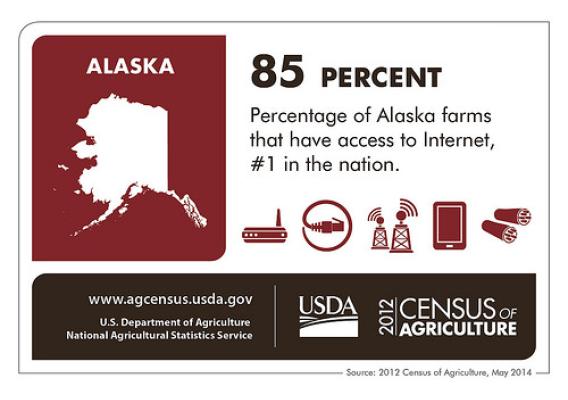
Despite the length of our growing season, according to the 2012 Census of Agriculture, there are 762 farms in Alaska, up 11 percent from the last Census, conducted in 2007. Nearly 834,000 acres of our land is dedicated to farming and ranching. In 2012, Alaskan farms produced nearly $59 million worth of agriculture products. By the way, nearly a third of all of the farms in Alaska are run by women, significantly outpacing the national percentage.