
snotel

Where Passion Meets Purpose: The Snow Survey

“To say I enjoy my job is an understatement,” said Hydrologist Randy Julander. “Monday is my favorite day of the week, because I get to go back to work.”

As the Snow Survey Data Collection Officer in Utah, Julander’s job is a mix of science, adventure and artistry. He weaves information from data. “Data are just numbers on a page; but information - now that’s something meaningful, something that informs decision makers,” he explained.

Interactive Map Compares Past and Present Snowpack - Western Snowpack Levels Very Low

Western snowpack, where it remains, is in full melt.

All along the Cascades and Sierra Nevada are ski courses that never opened, bare mountains and snowless SNOTEL sites where snowpack is measured. Where snow accumulated, it melted prematurely during a warm March. One of the most common questions for snow surveyors has been: how does this winter compare to the past?

A new, interactive map shows you exactly how it compares. The online map, just released by the USDA’s Natural Resources Conservation Service, shows regularly updated current conditions - alongside historical records - for the entire NRCS snow survey network.

How USDA's Snow Survey Program Got Started

James E. Church was a man who answered his calling. Like a real-life Indiana Jones, Professor Church pursued adventure around the world, ending a war and helping to found the Snow Survey Program on the way. Every hero needs a cause; Church found his in snow.

Born in Michigan in 1869, Church moved west in 1901 to teach classics and art history at the University of Nevada, Reno. The nearby Sierra Nevada fascinated him. He hiked there often, publishing his mountaineering accounts in the Sierra Club newsletter.

Surveyors Learn to Measure Snow, Prepare for Risks in Remote Mountains

If you live in the western United States and you’re sipping a glass of water, irrigating your crops, lighting your home with hydrological-sourced energy, or enjoy skiing or fishing, you’re probably using information made available from USDA’s snow survey program.

Snow provides 50 to 80 percent of the western water supply and while many agencies, utilities, Tribes and others have a role in snow surveys, USDA’s Natural Resources Conservation Service (NRCS) leads efforts to make sure all the players use accurate and consistent methods and come home safely. NRCS just released its February forecast.

Soil and Climate Data Help Farmers Reduce Severe Weather Risks

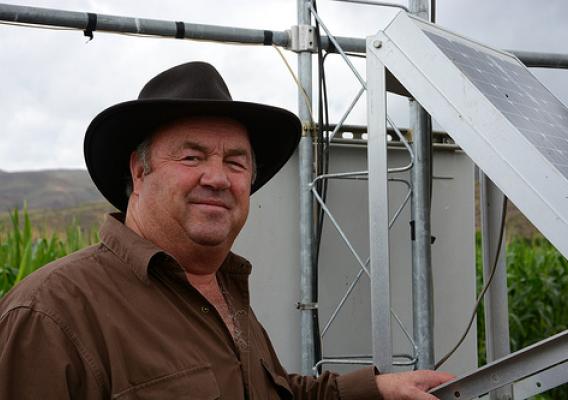
Utah dairyman Dee Waldron watches the weather closely. He wants clear, up-to-date weather and climate information anytime and anywhere that help him make critical farming decisions, such as when to irrigate, plant and harvest.

Waldron operates a dairy and feed grain farm in Morgan County, just east of Salt Lake City. This area is considered a high mountain desert and is not very productive without annual mountain streamflows stored in irrigation reservoirs.

“Before, I used to take a shovel in the field, dig down, and guess by feeling how much moisture was available for my crops,” Waldron said.  “Now I use my computer and iPhone to access the local weather forecast, the amount of soil moisture, the snow levels in the mountains, the amount of water in the river, and even the soil temperature. This really helps us as agricultural producers.”

Final Yearly Snowpack Forecast Divides West into a Wet North and Dry South

Every winter Westerners look to the mountains and may not realize they’re peering into the future. More snow cap means more water come spring and summer. Many lives and livelihoods depend on nature’s uneven hand.

Thanks to USDA’s National Water and Climate Center, what used to be speculation is now science. Through a network of high-elevation weather stations across the West, the center accurately forecasts how much water Western states will receive from snowmelt.

The data benefits everyone in the path of the streamflow. The center’s water supply forecasts empower states to take action to prevent flooding or prepare for drought. Some farmers look to the water supply forecast when deciding what crops to grow. It’s like playing chess with nature, and you can almost see nature’s next move.

Water Supply Forecast Shows Record Snow in Northern Parts of West, Parched in Southwest

March storms increased snowpack in the northern half of the West but didn’t provide much relief for the dry southern half, according to data from the U.S. Department of Agriculture’s National Water and Climate Center (NWCC) in its April 2014 water supply forecast.

According to the Natural Resources Conservation Service (NRCS), most of Idaho, Montana, Wyoming, and northern parts of Colorado and Utah are expected to have near normal or above normal water supplies, according to the forecast.  Far below normal streamflow is expected for southern Oregon, California, Arizona, New Mexico, southern Utah and western Nevada.

Measuring the Value of Snow

A stormy February doubled the Mount Hood snowpack from five feet to ten – a relief for northern Oregon, which has been unseasonably dry. Hydrologists have told me about dramatic recoveries, but this is the first time I’ve witnessed it.

I recently joined Julie Koeberle, one of our hydrologists with USDA’s Natural Resources Conservation Service, to collect data that would be released in the March forecast from the agency’s National Water and Climate Center.

We snow-shoed out to the site and weighed the snow, and a local reporter tagged along to see how it’s done. Weighing snow allows surveyors to calculate the snow-water equivalent, in other words, how much water is in the snow. Light, fluffy snow contains less than dense, packed snow.

Recent Forecast Shows Limited Water Supply in Westernmost States

Limited water supplies are predicted in many areas west of the Continental Divide, according to this year’s second forecast by the National Water and Climate Center of USDA’s Natural Resources Conservation Service (NRCS).

Right now, snow measuring stations in California, Nevada and Oregon that currently don’t have any snow, and a full recovery isn’t likely, the center’s staff said.

USDA is partnering with states, including those in the West, to help mitigate the severe effects of drought on agriculture.

Year's First National Water Forecast Predicts Limited Supply West of the Continental Divide

A limited water supply is predicted west of the Continental Divide, according to the Natural Resources Conservation Service (NRCS) National Water and Climate Center (NWCC) data in its first forecast in 2014.

The NWCC also predicts normal water supply east of the Continental Divide and will continue to monitor, forecast and update water supplies for the next six months.

Monitoring snowpack of 13 western states, the center’s mission is to help the West prepare for spring and summer snowmelt and streamflow by providing periodic forecasts. It’s a tool for farmers, ranchers, water managers, communities and recreational users to make informed, science-based decisions about future water availability.