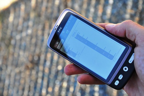
A new smartphone application, or “app,” is available as a free download for both iPhone and Android users to access soil survey information. The app, SoilWeb, combines online soil survey information with the GPS capabilities of smartphones.
The SoilWeb app is a portable version of the UC Davis California Soil Resource Lab’s Web-based interface to digital soil survey data from USDA’s Natural Resources Conservation Service (NRCS). Because the app provides soil survey information in a mobile form, it is particularly useful for those working in the field.
NRCS introduced the Web Soil Survey (WSS), an online tool for accessing soils information, a few years ago. This was a wonderful development for users of soils information—engineers, developers, farmers and many others—because WSS provides quick access to the most current data produced by the National Cooperative Soil Survey.
Until recently, a disadvantage of Web-based soil survey formats was that user access was limited to desktop computers with an internet connection. That’s one reason that NRCS soil scientist Dr. Dylan Beaudette, while still a graduate student at UC Davis, developed the SoilWeb app in collaboration with NRCS and the UC Davis California Soil Resource Lab.
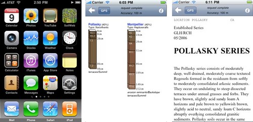
SoilWeb can retrieve a graphic summary of soil types in response to a user inquiry in the form of soil profile sketches. Each profile sketch shows soil horizons, often compared to a vertical ice cream sandwich made up of layers of soil. Soil names, locations and taxonomic categories are also shown.
Clicking on soil sketches sends the user to the corresponding Official Series Description, a user-friendly narrative of commonly used soil properties such as horizon depths, colors, texture and rock fragment content. Clicking on a soil name (listed above each sketch) provides the user with a more detailed description, including: physical and chemical properties, definitions and links to a variety of environmental databases.
This means that a farmer, rancher or even a backyard gardener could use a smartphone to gain an understanding of the soil type in the surrounding landscape. Soil health is a key factor in the success of plants—the type of soil determines what nutrients are needed, as well as how much water should be applied.
SoilWeb is useful even for users already familiar with NRCS’s Web Soil Survey, as it is much faster than pulling up soil survey information on a desktop or laptop computer.
Check out more conservation stories on the USDA blog.
Follow NRCS on Twitter.
Write a Response
Comments
this is an awesome app, my only suggestion is to do a ipad version. It will work on ipads, but retains the iphone size.
How cool is this! And from UC Davis too.
You are leaving out blackberry users. Tha app is no good if every one can't use it.
Not a new app. I've been using this for over a year now.
To bad all goverment phones are blackberrys
Excellent! I am so excited to use this with Agronomy students in the fall.
This is a great app! Think of the potential - 'Joshua Johnson "likes" this post, while standing on Mountview soil with 9% slope.'
It will take some adjusting to become comfortable with the metric measurements. The diagram is in centimeters, the explanations lists inches...whew!
My old soils professor would be so proud that I bothered to download this app!
I have been using this for more than a year. I also recommend the app "Coordinates" as it lets you type in GPS coordinates and will convert them to decimals or vice versa and then you can map to/from the coordinates. I use these apps everyday as a soil con, maybe USDA should be paying my iPhone bill?
What a great app. I've good mobile ESRI and AutoCAD versions on my iPhone. This is a great compliment to a truly mobile office for feild professionals.
Sorry for all those Blackberry folks, but that is a dead company with a tiny smartphone market share. No one really makes apps for them. You'll have better luck trying to watch new moive realease on Betamax.
Please start work on an ipad version.
Has this app been written for Microsoft phones?
Works great on my Droid Razr. Helpful in teaching Soil Management class at local community college's Natural Resource Management program.
Sorry for Blackberry users. This is another example of why I don't have a Blackberry - way too limited now.
my uncle would love this app. :) and i agree with the rest it should have an ipad app, it will definitely benefit those who doesn't use iphones.
I'm using this app on iphone. Works great
When will it be available for android?
Great idea!
I want to know soil topographic maps.
The SoilWeb app for smartphone is no longer being supported by the soil survey division, this app is extremely important for providing soils information at the users location. No other resource inventory maps (wetlands, geology) are available in this type of format. Please keep this app running with the new iOS and Android operating systems by funding the continued development of the SoilWeb for smartphone app.
@Robert Higgins - thank you for your comment. The Soil Science Division is currently looking at various options in 2018 for supporting SoilWeb and the varied work done by the University of California at Davis. Funds are limited but we do recognize the popularity and unique utility of what SoilWeb offers.
Soilweb is misleading and open to misinterpretation. User sees predominate soil type w/in the map unit and is not made immediately aware of the possibility of minor components. Soilweb should be linked to a map unit description, not the Official Series Description. At a minimum there should be an explanation to clarify the difference between a series concept and what the soil survey data is really conveying - the composition of a landscape segment and not a hole where the user is standing.
@Al Averill - Based on your comment, it sounds like you may be using an old version of SoilWeb? The updated version shows map unit composition.
This app needs to be updated for current IPhone ios. it will not work on current model iphones>
When the app will become compatible with the newest iOS opera rating system. My husband relies on this app daily and is unable to use it since his last update to his phone
How does this deals with perturbation processes, apart from other chemical & physical processes?
How does this deals with pedoturbation processes, apart from other chemical & physical processes?
@Jabiru Aliyu - thank you for your comment. SoilWeb does not inherently address pedoturbation as a soil function. It does, however, provide the user with current soil physical, chemical, and biological information at their current site which can be used for helping to understand a wide range or soil processes.
Please can this app be used in Africa? Specifically GHANA?