What lengths would you go to for the pursuit of science?
That’s a question I asked myself when I had the opportunity to participate in data collection at the Glacier Lakes Ecosystem Experiments Site with John Frank and John Korfmacher, Electronics Engineer and Physical Scientist respectively, at the Forest Service’s Rocky Mountain Research Station.
The Glacier Lakes Ecosystem Experiments Site, or GLEES, is located in the Snowy Range of the Medicine Bow Mountains, within the Medicine Bow National Forest in Wyoming. The remote site’s 600 hectares (1,480 acres) are composed of a watershed located in mountainous terrain at 3,200 to 3,500 m (10,500 to 11,500 ft.) elevation.
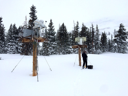
With its unique hydrological and topographical features and diversity of plant species, this site has been ideal for investigating the effects of atmospheric and climate changes on alpine and subalpine ecosystems. There has been a rich history of research at the site, and an extensive collection of information, spanning the fields of meteorology, hydrology, geology, and ecology, dating back to the 1930s. Currently, there are two major sites for meteorological and air quality monitoring, one located by the Glacier Lakes and the other by the Brooklyn Lake.
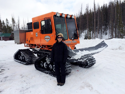
Each Tuesday, Frank and Korfmacher make the trek from the Rocky Mountain Research Station headquarters in Fort Collins, Colorado, to the site. They, sometimes joined by colleagues, have made this trek without fail each week for more than a decade regardless of weather conditions and holidays. On this particular excursion in early February, the deep snow drifts meant having to switch from the Forest Service rig to a Sno-Cat, a special tracked vehicle for heavy snow conditions, to reach the monitoring sites. But even the Sno-Cat can only get you so far in such remote, forested terrain.
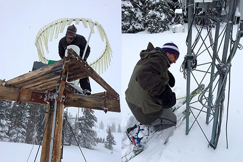
The last portions of the journey to the monitoring towers required snowshoeing/cross-country skiing. Although this time the trek was only a few hundred feet, during early- and late-season conditions when there is more snow it could be up to two miles.
It is physically demanding work, and the passion and dedication that these men have for the land and their research blew me away. They are proud of their contributions to national and international monitoring networks. For example, precipitation is collected at the site as part of the National Atmospheric Deposition Program/National Trends Network, which monitors the chemical composition of precipitation, such as rain or snow, to determine trends in air and water quality. Carbon dioxide in the atmosphere is also measured at the site, as part of the Long-term Flux Measurement Network of the Americas (AMERIFLUX) and global FLUXNET. This information contributes to global efforts to better understand atmospheric processes and movements of chemical compounds, and how they affect high-elevation ecosystems. Collecting the data is only a small portion of their jobs. Frank studies how ecosystems exchange carbon, water, and energy with the atmosphere, especially following a spruce beetle outbreak. Korfmacher investigates the deposition of pollutants from the atmosphere and how it impacts local hydrology.
My one day with Frank and Korfmacher was filled with firsts for me – riding a Sno-Cat, snowshoeing, and participating in data collection at one of the coldest, most remote sites I’ve ever been. But for these guys, it’s just another day at the office.