
brad rippey

Nation’s Wettest 12-Month Period on Record Slows Down 2019 Planting Season

The contiguous United States recently completed its wettest May to April period on record, according to the National Oceanic and Atmospheric Administration’s National Centers for Environmental Information (NOAA/NCEI). From May 2018 to April 2019, an average of 36.20 inches of precipitation fell across the Lower 48 states, 6.25 inches above the 20th century mean. In fact, it was the nation’s wettest 12-month period on record, regardless of which months are chosen.

USDA Meteorologist Talks With Producers "In the Field"

This post is part of the Science Tuesday feature series on the USDA blog. Check back each week as we showcase stories and news from the USDA’s rich science and research portfolio.

Ever wonder how USDA is able to make a forecast – either economic or weather?  It takes a lot of work.

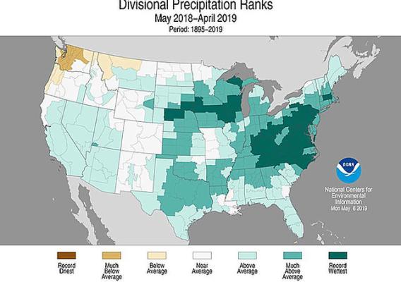
Last week, USDA’s U.S. meteorologist Brad Rippey met with producers in southwestern Michigan. The first stop, on a rainy, stormy morning, was with Bryan Bixby, owner of Bixby Orchards in Berrien Springs.  Bixby described how spring wetness has been detrimental to fieldwork and crop quality.  For example, wet, humid conditions shortened the southwestern Michigan strawberry season and reduced fruit quality.  In addition, wetness has impeded Bixby's efforts to complete soybean planting.  During a tour of his orchards, Bixby described how the recent winter was Michigan's harshest since 1976-77, causing substantial mortality in peach trees -- requiring him to buy peaches from South Carolina in order to meet customer demand.

Have Crop Questions? NASS has Answers!

When it comes to growing crops, weather is a constantly changing variable. These past few years, grain farmers have been on a veritable weather roller coaster. The floods of 2011 were followed by perfect spring planting conditions in 2012. Conditions deteriorated rapidly, resulting in one of the worst droughts in at least 25 years. This year, the weather has thrown yet another knuckleball at farmers, idling field work and reducing plantings to the slowest pace since 1984 in many areas.

USDA and National Weather Service Team Up to Provide 2013 Weather Outlook

USDA’s Agricultural Outlook Forum featured a weather outlook for 2013 during the final session of the two-day event in Arlington, Virginia.  Prior to the 2013 outlook—which was presented by National Weather Service (NWS) meteorologist Anthony Artusa—USDA meteorologists Brad Rippey and Eric Luebehusen recapped some of the key U.S. and Northern Hemisphere agricultural drought highlights, respectively, from the summer of 2012.  In particular, the U.S. heartland suffered through its worst agricultural drought in a generation, with effects similar to those observed in 1988.  Grain corn was the hardest-hit U.S. row crop, while the livestock sector was severely affected by a lack of feed due to drought-ravaged rangeland and pastures.  Meanwhile, a hotter-, drier‐than‐normal summer impacted crops from southern Europe into central and eastern Russia.  Hardest-hit crops included corn in Italy, Romania, and Bulgaria, as well as spring wheat in Russia’s Siberia District.