
national weather service

Navajo and Hopi Expand the Community Collaborative Rain, Hail and Snow Network

Susie Wauneka has discovered a unique way to serve her community; by watching the weather. Wauneka is a proud member of Navajo Nation and is a Navajo Community Health Representative, providing critical health care services for members of the Nation. In December 2015, she discovered yet another way to serve—by using a Community Collaborative Rain, Hail and Snow (CoCoRaHS) precipitation gauge to track the amount of rain and snow that falls.

The CoCoRaHS network is a unique grassroots network of thousands of trained volunteers of all ages and backgrounds working together to improve meteorological science by measuring and reporting precipitation amounts (rain, hail, and snow). CoCoRaHS is the largest provider of daily precipitation observations in the United States. The data from these observations are used by USDA and the National Oceanic and Atmospheric Administration (NOAA) for tools such as the United States Drought Monitor.

USDA and National Weather Service Team Up to Provide 2013 Weather Outlook

USDA’s Agricultural Outlook Forum featured a weather outlook for 2013 during the final session of the two-day event in Arlington, Virginia.  Prior to the 2013 outlook—which was presented by National Weather Service (NWS) meteorologist Anthony Artusa—USDA meteorologists Brad Rippey and Eric Luebehusen recapped some of the key U.S. and Northern Hemisphere agricultural drought highlights, respectively, from the summer of 2012.  In particular, the U.S. heartland suffered through its worst agricultural drought in a generation, with effects similar to those observed in 1988.  Grain corn was the hardest-hit U.S. row crop, while the livestock sector was severely affected by a lack of feed due to drought-ravaged rangeland and pastures.  Meanwhile, a hotter-, drier‐than‐normal summer impacted crops from southern Europe into central and eastern Russia.  Hardest-hit crops included corn in Italy, Romania, and Bulgaria, as well as spring wheat in Russia’s Siberia District.

NRCS Snow Surveyor Collects Vital Water Data, Lives Dream Job

Koeberle’s job carries her over mountains by helicopter and horse, snowshoes and skis. She has encountered grizzly bears, avalanches and wolves and visited ridges that few people have seen.

Koeberle is a hydrologist and snow surveyor for USDA’s Natural Resources Conservation Service (NRCS) and works on the agency’s snow survey team—a group of specially trained scientists who maintain snow gauges that are important to farmers, business owners and many other people in the West.

Early Warning and Detection System to Help New Mexico Communities

New Mexico experienced in June two catastrophic wildfires—the Whitewater Baldy Complex Fire and the Little Bear Fire. One consequence of those fires has been flash flooding. Water runs off more quickly during rainstorms in areas where fires have stripped the landscape. These floods can happen with very little notice, endangering communities downstream.

La Niña Triggers Extremes in U.S. Weather

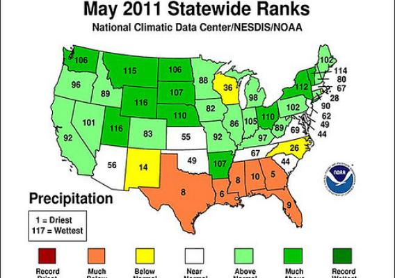
No matter where you live in the United States, you’ve probably noticed that the weather just hasn’t been “normal” in recent months.  Our nation has experienced widespread flooding, relentless drought, expansive wildfires, and devastating tornadoes – sometimes all at once.

Some of the blame has to be directed at La Niña, a cooling of the waters of the central and eastern equatorial Pacific Ocean.  La Niña developed during the summer of 2010, leading to a profound influence on North American weather from the autumn of 2010 through the spring of 2011.  In typical fashion, La Niña forced the subtropical jet stream northward, resulting in drought development, expansion, and intensification in the South.  At the same, time jet stream disruptions induced by La Niña led to persistently cool, wet conditions across roughly the northern half of the U.S.