
weather

Northern Plains Regional Climate Hub Extension and Outreach Team Develop Regional Efforts

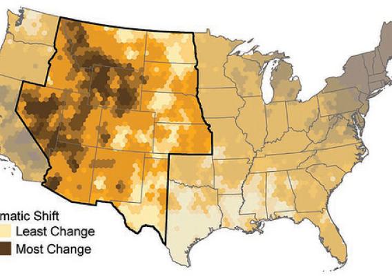
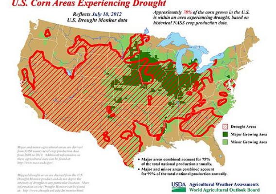
All this month we will be taking a look at what a changing climate means to Agriculture. The ten regional USDA Climate Hubs were established to synthesize and translate climate science and research into easily understood products and tools that land managers can use to make climate-informed decisions. The Hubs work at the regional level with an extensive network of trusted USDA agency partners, technical service providers, University collaborators, and private sector advisers to ensure they have the information they need to respond to producers that are dealing with the effects of a variable climate. USDA's Climate Hubs are part of our broad commitment to developing the next generation of climate solutions, so that our agricultural leaders have the modern technologies and tools they need to adapt and succeed in the face of a changing climate.

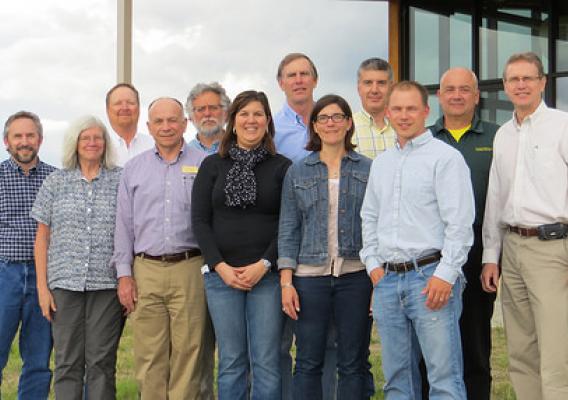
The USDA Northern Plains Regional Climate Hub (NPRCH) partnered with the 1914 Cooperative Extension programs in Montana, Wyoming, Colorado, North and South Dakota, and Nebraska to develop and deliver science-based, region specific information and technologies to agricultural and natural resource managers to enable them to make climate-informed decisions.  The team has met monthly since June 2015, and through their efforts and partnership with the NPRCH they reached out to Extension colleagues to develop relevant projects that meet stakeholder needs in the region.

Since becoming partners, the NPRCH Extension and Outreach participants have developed the following three efforts, which they will work on during the coming year.

Unleashing Climate Data to Empower America's Agricultural Sector

Cross-posted from the White House Blog:

Today, in a major step to advance the President’s Climate Data Initiative, the Obama administration is inviting leaders of the technology and agricultural sectors to the White House to discuss new collaborative steps to unleash data that will help ensure our food system is resilient to the effects of climate change.

More intense heat waves, heavier downpours, and severe droughts and wildfires out west are already affecting the nation’s ability to produce and transport safe food. The recently released National Climate Assessment makes clear that these kinds of impacts are projected to become more severe over this century.

USDA Meteorologist Talks With Producers "In the Field"

This post is part of the Science Tuesday feature series on the USDA blog. Check back each week as we showcase stories and news from the USDA’s rich science and research portfolio.

Ever wonder how USDA is able to make a forecast – either economic or weather?  It takes a lot of work.

Last week, USDA’s U.S. meteorologist Brad Rippey met with producers in southwestern Michigan. The first stop, on a rainy, stormy morning, was with Bryan Bixby, owner of Bixby Orchards in Berrien Springs.  Bixby described how spring wetness has been detrimental to fieldwork and crop quality.  For example, wet, humid conditions shortened the southwestern Michigan strawberry season and reduced fruit quality.  In addition, wetness has impeded Bixby's efforts to complete soybean planting.  During a tour of his orchards, Bixby described how the recent winter was Michigan's harshest since 1976-77, causing substantial mortality in peach trees -- requiring him to buy peaches from South Carolina in order to meet customer demand.

Rural Development Helps Restore Water Supply to Town of Gifford after Devastating Tornado

Four months after a tornado ripped through the town of Gifford, Illinois, destroying its water tower, 70 homes, and damaging 40 others, visible and emotional aftereffects remain.

On November 17, the day the tornado touched down, I called my colleague and Gifford resident Molly Hammond, who wistfully noted during our conversation, that “Everyone is all right.  But not everything is all right!”

No doubt her sentiments reflected those of Gifford’s other 1,000 residents.

It’s Said That No One can Predict the Weather, but Scientists at the Ag Outlook Forum Give it a Shot

Weather….  We all care about it. In many communities, local TV and radio weather forecasters are celebrities, and for good reason.  While we can’t do much about the weather, it affects us all every day.

During last week’s Agricultural Outlook Forum two sessions drew exceptionally large crowds.  One was the Friday afternoon “Weather and Agriculture” segment and another was the morning “Markets and Weather” presentation.  While no one can say for sure what the weather outlook will be for the 2014 summer growing season, Brad Rippey, agricultural meteorologist with USDA’s Office of the Chief Economist (OCE), Eric Luebehusen, OCE ag. meteorologist and Anthony Artusa, meteorologist with the Climate Protection Section of the National Oceanic and Atmospheric Administration made some observations and predictions in the afternoon session.  The snowpack in the West’s Sierra Nevada is far below normal.  The Western winter wet season has been a bust, with winter precipitation less than 10 percent of average in some areas.  California, the Great Basin and southern Great Plains are in drought.  The meteorologists said California, the lower gulf coast and much of New Mexico, Arizona and Texas could see above normal temperatures and below normal precipitation in March, April and May.  According to Rippey, “We need a miracle March in 2014 to avoid major problems in California.”  The most current information is available through NOAA’s Seasonal Drought Outlook map and the USDA drought monitor.

USDA and National Weather Service Team Up to Provide 2013 Weather Outlook

USDA’s Agricultural Outlook Forum featured a weather outlook for 2013 during the final session of the two-day event in Arlington, Virginia.  Prior to the 2013 outlook—which was presented by National Weather Service (NWS) meteorologist Anthony Artusa—USDA meteorologists Brad Rippey and Eric Luebehusen recapped some of the key U.S. and Northern Hemisphere agricultural drought highlights, respectively, from the summer of 2012.  In particular, the U.S. heartland suffered through its worst agricultural drought in a generation, with effects similar to those observed in 1988.  Grain corn was the hardest-hit U.S. row crop, while the livestock sector was severely affected by a lack of feed due to drought-ravaged rangeland and pastures.  Meanwhile, a hotter-, drier‐than‐normal summer impacted crops from southern Europe into central and eastern Russia.  Hardest-hit crops included corn in Italy, Romania, and Bulgaria, as well as spring wheat in Russia’s Siberia District.

Agricultural Weather and Drought Update - 7/20/12

Visit www.usda.gov/drought for the latest information regarding USDA’s Drought Disaster response and assistance.

The drought of 2012 has rapidly expanded and intensified, covering 64% of the contiguous United States – according to the U.S. Drought Monitor – by July 17.  Three months ago, that figure stood at 37%, and at the beginning of the year, only 28% of the lower 48 states had drought coverage.

Agricultural Weather and Drought Update - 7/16/12

Weekend thundershowers provided limited and localized relief to a few Midwestern fields, but most of the Corn Belt remains in dire need of moisture.  Currently, very hot weather is building back into the Midwest. High temperatures above 100°F can be expected in portions of the western Corn Belt for the remainder of the week. The eastern Corn Belt should experience some mid- to late-week heat relief, but only scattered showers will accompany the transition to cooler weather. Like last week, substantial drought relief will be confined to the Southeast.

Agricultural Weather and Drought Update – 7/12/12

On July 11, USDA’s World Agricultural Outlook Board cut the estimate for the 2012 U.S. corn crop by 1.82 billion bushels to “reflect expected impacts of persistent and extreme June and early-July dryness and heat across the central and eastern Corn Belt.”  The 12% cut, which left the projected U.S. corn production at 12.97 billion bushels, is a direct result of the nation’s worst drought in a generation—since 1988. Yesterday, Agriculture Secretary Tom Vilsack also announced that more than 1,000 counties across in 26 states would be designated as disaster areas due to the worsening drought.

La Niña Triggers Extremes in U.S. Weather

No matter where you live in the United States, you’ve probably noticed that the weather just hasn’t been “normal” in recent months.  Our nation has experienced widespread flooding, relentless drought, expansive wildfires, and devastating tornadoes – sometimes all at once.

Some of the blame has to be directed at La Niña, a cooling of the waters of the central and eastern equatorial Pacific Ocean.  La Niña developed during the summer of 2010, leading to a profound influence on North American weather from the autumn of 2010 through the spring of 2011.  In typical fashion, La Niña forced the subtropical jet stream northward, resulting in drought development, expansion, and intensification in the South.  At the same, time jet stream disruptions induced by La Niña led to persistently cool, wet conditions across roughly the northern half of the U.S.