
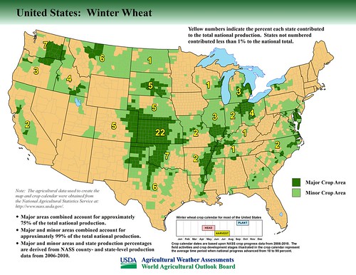
A total of 40 new maps have been prepared, showing major crop-producing areas in the United States, China, India, Pakistan, and South Africa. Earlier versions of these maps appeared in the Major World Crop Areas and Climatic Profiles (MWCACP) handbook that contains climatological data, agricultural statistics, and crop calendar information for major agricultural areas worldwide, and serves as a reference for evaluating the effects of weather on world crop production. The new maps, listed by country and commodity, supplement the MWCACP publication by updating illustrations of cropping patterns in these countries:
- United States: barley, corn, cotton, flaxseed, peanuts, rice, sorghum, soybeans, sugarbeets, sugarcane, durum wheat, spring wheat, and winter wheat
- China: corn, cotton, groundnuts, rapeseed, rice, soybeans, sugarcane, and wheat
- India: corn, cotton, groundnuts, rapeseed, rice, soybeans, sugarcane, and wheat
- Pakistan: cotton, rice, and wheat
- South Africa: corn, cotton, oranges, soybeans, sugarcane, sunflowers, and wheat
Write a Response
Comments
are there Google Earth enabled Shapefile Sets or .kmz files for all these data sets?
Hi
I would like to get Crop production areas in China in a GIS format.Can you please direct me to the most recent data-set . Thank you.
I am looking at the latest in National Geographic where they show the United States by product which very interesting. Now what is rapeseed and how is it used? Thanks.
Is there shapefiles for these datasets?
@Bryan Petersen - Thank you for your inquiry. Unfortunately, shapefiles for these datasets are not available to the public.
I get a NOT FOUND message when trying to connect to the link that is provided:
" PDF versions of these maps, and the MWCACP publication (1994 revised), are available at: http://www.usda.gov/oce/weather/pubs/Other/MWCACP/index.htm."
The webpage of Major World Crop Areas and Climatic Profiles cannot be found.
@Mei Yu - thank you for your comment. That link is now outdated and you can find this content at this following link: ipad.fas.usda.gov/cropexplorer.
Are these maps available on the web, if so, what is the Internet address? thanks.
@Keith - thank you for your comment. You can find this content at this following link: ipad.fas.usda.gov/cropexplorer.
Thanks for providing these marvelous services. Just wonder why web developers don't provide a direct link of IPAD from the USDA website? It seems IPAD is under Foreign Agriculture Service but there is no means to access to it from any website unless you know the direct link.
Hi - Where are these updated maps? I cannot find them - only the older ones. https://ipad.fas.usda.gov/rssiws/al/us_cropprod.aspx
@Jenny - thank you for your comment. The content within the FAS link you reference is the latest information on the page. You may also find other maps at the following link: ipad.fas.usda.gov/ogamaps/cropproductionmaps.aspx.
How can i access this data?
@Joe Hillegass - thank you for your comment. You can find this content at this following link: ipad.fas.usda.gov/cropexplorer.