


This post is part of the Science Tuesday feature series on the USDA blog. Check back each week as we showcase stories and news from USDA’s rich science and research portfolio.
When we think about space missions, we tend to look toward the stars to planets like Mars where robotic rovers roam, gathering data and sending it back to Earth. Rarely do we think about missions closer to home. But a view of Earth from 426 miles above is helping us monitor droughts, predict floods, improve weather forecasts and assist with crop productivity.
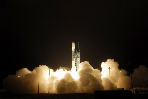
This year, the National Aeronautics and Space Administration (NASA) launched a new satellite called SMAP (Soil Moisture Active-Passive) with the help of a team that included U.S. Department of Agriculture (USDA) hydrologist Susan Moran at the Agricultural Research Service’s (ARS) Southwest Watershed Research Laboratory in Tucson, Arizona, and physical scientist Wade Crow and hydrologist Thomas Jackson at ARS’s Hydrology and Remote Sensing Laboratory in Beltsville, Maryland.
ARS scientists played a key role in designing and implementing SMAP—an orbiting observatory that measures the amount of water in the top layer of the soil everywhere on Earth. SMAP gathers soil moisture data that can help track diseases and famine, predict weather and climate patterns, assist emergency workers’ response to natural disasters and let farmers know what crops to plant.
“We’ve seen impressive advances in our ability to produce crops on a given area of soil, but have also retained susceptibility to climate events, particularly droughts that occur when there is inadequate soil water for crops,” Crow says. “The idea is to better predict and monitor droughts so they don’t turn into food crises, and soil moisture is the most direct and earliest indication of drought.”
SMAP provides the best global view of soil moisture to date, Crow says. Therefore, it has the potential to help monitor global food production. It’s the best soil moisture sensor ever deployed due to its resolution, accuracy, global coverage and repeat time.
Before the satellite was launched, volunteer users around the world could put SMAP’s simulated data to use, Moran says. “We wanted to make sure our products would be as good as possible and easy to access. In return, these users provided feedback on how SMAP could help them.”
Early users included those in agriculture, weather, human health, emergency response and military readiness. Data were used to monitor droughts, predict floods and even to predict the water supply in New York City, Moran says.
“Some used the data to predict large regional dust storms that affect the health of millions of people in Saharan Africa and throughout the Middle East,” she adds. “In Germany, the data were used to map sea ice in hopes of improving maritime navigation, and at Texas A&M University, researchers looked at the impact of hurricanes on power outages.”
SMAP will release the first data products to the public in August. To learn more, go to http://smap.jpl.nasa.gov/.